Welcome

Showing posts with label Guizhou Province. Show all posts

Saturday, 14 November 2015

Off the beaten track in Zhenyuan, Guizhou province


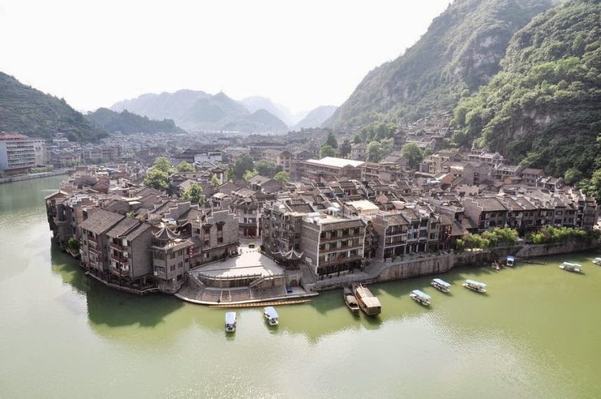
The picturesque town of Zhenyuan in Guizhou Province offers a quiet retreat from city life. Located two hours east of the city of Kaili, Zhenyuan occupies a beautiful spot along the Wuyang River, nestled between rows of grassy hills. The ancient town has historic sites to browse and mountains to clamber up. The city has been developed with some tourist amenities, but hasn't yet been overrun by crowds.

Buses from Kaili to Zhenyuan run every two hours.


Source: CRI by William Wang 

Friday, 11 September 2015

Terraced fields in SW China


Photos taken on September 10, 2013 show the scenery of terraced fields in Guizhou province.


Source: Xinhua

Sunday, 2 August 2015

Wanfenglin: national geological park in Xingyi, Guizhou


A visitor takes photos of Wanfenglin in Xingyi, Guizhou province, July 31, 2012. Wanfenglin, which literally means Forest of Ten Thousand Peaks, is a national geological park and also a tourism attraction in Xingyi city.

(Source: Xinhua)

Tuesday, 26 May 2015

A traveler's treasure trove

Source: By Craig Mcintosh (China Daily)

While poor in material wealth, Guizhou province is rich in culture, scenery and much else a visitor would desire. Craig McIntosh reports in Guizhou.

If you collected every article ever written about Guizhou province - news or travel - and used them to make a word cloud, it's a good bet that the two largest words would be "poverty" and "beauty". They certainly featured heavily in everything I read before heading out to this southwestern province. Going by people's incomes, Guizhou is certainly one of the poorest areas in China, largely because its rough, karst terrain has made it hard for industry to move in. It is also true that these same mountains, rivers and valleys causing the hardship are simply a delight to behold, while the area's temperate climate, and diverse and colorful ethnic population combine to create a priceless experience.

What I didn't read about is the mind-blowing food (in both senses of the word - glorious and spicy) and the copious amounts of baijiu (clear Chinese spirits) that I'd be expected to down at every meal.

For the vast majority of visitors, their introduction to the province is the airport or train station at Guiyang, the capital. The city has its fair share of attractions, such as the laidback Huaxi Park and the 400-year-old Jiaxue Tower. But like in other parts of Southwest China, the fun of Guizhou lies in the countryside.

Luckily, Guiyang is slap-bang in the center of the province, which makes it the perfect jumping-off point for anyone looking to explore rural China. Major highways lead north to the ethnic villages of Zunyi, west to the picturesque county of Kaili or southwest to the stunning Huangguoshu Waterfall and the Maling River beyond.

On this occasion, as it was mid-April, I plumped for the blooming forests of Bijie, a city about 165 km away in the northwest.

Be aware that no trains run to these parts, so taking a bus or car are the only options - and even relatively short journeys can take time. If, like me, you're adverse to tedious road trips, have no fear. It's a pleasure just sitting and staring through the window.

Winding cliff roads, steep valleys and a green-blue horizon that looks like a tree-covered radio wave - you won't want to blink. I almost filled my camera's memory card within the first couple of hours.

I stayed in Qianxi, a county in Bijie that's fairly developed compared to other parts of the province. Although rather generic in looks, its redeeming quality is the nearby Baili Azalea Belt.

Stretching for about 50 km, the belt has about 40 different kinds of azalea, which together form kaleidoscopic peaks of pinks, reds, purples and yellows. It even boasts the biggest azalea shrub in the world, the "King of Azaleas", which is estimated to be 1,000 years old.

The flowers bloom in March and April, so expect the usual ren shan ren hai (a reference to crowds as "mountains and seas of people"). Despite the inevitable crowds though, there's lots of room to wander and plenty of pavilions offering hilltop views of the forest.

Bijie has been a pilot zone for tourism development since the late 1980s, when the Party secretary of Guizhou was a certain Hu Jintao, now the country's president.

It has obviously benefited from the large injection of cash, which explains why some parts have a recently built look. Yet the cash has also had another effect: It has allowed many migrant workers from these parts to return home.

Qianxi is full of family-run guesthouses ready to host the expected influx of Chinese and foreign guests. That means you're unlikely to struggle in finding cheap accommodation, and it provides a better chance of getting in touch with the local culture than staying at a hostel and hotel, especially in areas with ethnic groups.

The locals are extremely friendly and more than happy to share a historical tale or two to anyone willing to listen, although even Mandarin speakers will find the local dialect hard to follow.

Like Yangshuo, a backpacker retreat in the neighboring Guangxi Zhuang autonomous region also famed for its grassroots hospitality, the Qianxi countryside caters to all, from the hyperactive to the downright lazy.

Whether you want to walk, run or cycle through the rolling hills and colorful villages, or you want to simply enjoy a book by a field of rapeseed flowers, you can.

As well as the Baili Azalea Belt, the area has Caohai Lake, the largest natural freshwater lake. It's blessed with a plethora of plants and rare wildlife, including the red-crowned crane, the white stork and the white-tailed sea eagle. Close by is also Jiudongtian, a famous collection of valleys and limestone caves.

Heading back toward the capital, I stopped in Dafang, a town that tourism authorities have been working hard to return to its former glory.

The main street of this county town has been revamped to appear like it did 100 or so years ago, with several attractions along the way, such as the former residence of a Yi ethnic queen that has been converted into a museum.

Further out, there is also a massive replica of an ancient palace, which holds scores of exhibits covering the area's rich and diverse history. It's often used as a film location for period TV dramas.

However, what the urban center lacks in authentic charm, the outlying rural areas more than make up for in culture. Dafang is surrounded by ethnic villages - Yi, Miao and Bouyi - and each has its own rituals, snacks, wines and festivals.

During my stay, I was treated to a Yi fire party, which basically involves singing, dancing and telling stories around a large fire. Oh, and drinking cup after cup of baijiu and mijiu, another kind of rice wine.

Thinking back, it probably wasn't the best idea to have a hangover the morning I headed to Bijie's most famous landmark, Zhijin Cave.

Roughly two hours by bus from Dafang, the massive karst cave was formed about 1.2 million years ago but was only discovered in the 1980s. I'm told that, up until then, it was just somewhere the local ethnic Miao children played.

And what a playground!

Covering the length of more than 12 km (only half is open to visitors), it has more than 100 crystalline formations, each of which have been named according to its appearance. There's the "Pipa", the "Mushroom" and the "Drum", as well as the imposing "Silver Rain Tree", a stalactite that stands 17 meters high.

Sections are varied, with some wide and tall, others narrow and tight, while the lighting effects - green, red and purple - highlight the most important formations.

It's a must-see for visitors, but my advice would be to wear sensible shoes (that 6-km walk is the equivalent of walking down one hill and up another) and take a warm jacket.

Exhausted after my underground trek, I boarded a bus heading back to the capital.

All I wanted was to get some sleep, but that's the thing about Guizhou - close your eyes for a second and you could miss something amazing.

Friday, 7 November 2014

Land of peace for Tujia minority - Yunshe Village


Yunshe village is in Jiangkou county's Taiping town and is surrounded by Fanjing Mountain and Taiping River in Guizhou province. The perfect location made the village a place to get peace of mind. It is also known as "China's No. 1 village for the Tujia minority".


Source: cri via china.org

Sunday, 26 October 2014

China's top 7 Danxia landforms


Mount Danxia (Guangdong)

Mount Danxia is a noted scenic area near Shaoguan in the northern part of Guangdong province. The Danxia mountain is formed from a reddish sandstone that has eroded over time forming a range of mountains surrounded by curvaceous cliffs and unusual rock formations (Danxia Landform). It is described by the local signage as a "world famous UNESCO geopark of China." There are a number of temples located on the mountain range and visitor can enjoy many scenic walks in the area. There is also a river that winds through the mountain area and boat trips along the river are offered to visitors.

Danxia Mountain also has a few unique stones such as the Yang Yuan Stone, Yin Yuan Stone, Breasts stone, Sleeping Beauty and other attractions which make Danxia Mountain a "natural sex culture museum." Particularly noted are two formations: a stone pillar called the Yangyuan ("male/father stone") that bears a remarkable resemblance to a phallus and the Yinyuan hole, which somewhat resembles the female labia.

In the 2010 UNESCO list of world heritage sites, Mount Danxia was listed as a natural World Heritage Site as part of China's Danxia landform

Best travel time: All year around

Wuyi Mountains (Fujian)

The Wuyi Mountains are a mountain range located in the prefecture of Nanping, in northern Fujian province near the border of Jiangxi province. The mountains were listed as a UNESCO World Heritage Site, for cultural, scenic, and biodiversity values in 1999.

The Wuyi Mountains are located between Wuyishan City, Nanping prefecture in Fujian province and Wuyishan,in the city of Shangrao in Jiangxi province. The world heritage site has a total area of 99.975 hectares that is divided into four core parts: the Nine-Bend Stream Ecological Protection Area (36,400 ha) in the center, flanked by the Wuyishan National Nature Reserve (56,527 ha) to the west and the Wuyishan National Scenic Area (7,000 ha) to the east. The fourth part, the Protection Area for the Remains of Ancient Han Dynasty (48 ha) is located in a separate area about 15km to the south-east of the other lcoations. The core parts are surrounded by an additional buffer zone of 27,888 ha.

Best travel time: summer, although it's very hot then but everything is exuberant.

The golden lake (Fujian)

The golden lake is located in Taining County in the northwest of Fujian province. A man-made lake sits at the upper reach and is about 60 kilometers long, and has a capacity of 8.7 hundred million cubic meters. The Golden Lake is surrounded by mountains and verdant forest. Stone bamboo shoots stand tall with springs flowing through them. There are more than 1,000 historic sites, such as the Baishuiji waterfall, Canglu Temple, the lover's peak, great Chibi, above the water, the five-kilometer-long calm lake, to name a few. These features make up the unique scenic spot. The Golden Lake is also regarded as "Lake of Gold" by tourists at home and abroad.

Best travel time: all year around

Mount Longhu (Jiangxi)

Mount Longhu is located in Jiangxi province. It is famous for being one of the birthplaces of Taoism, as many Taoist temples were originally built upon the mountainside. It is particularly important to the Zhengyi Dao as the Shangqing Temple and the Mansion of the Taoist Master are located here. It is known as one of the Four Sacred Mountains of Taoism.

Two of the temples are of Immortal City and Zheng Yi, all founded by Zhang Daoling, the Han Dynasty founder of the religion. There are more Taoist temples in nearby Shangqing. One of the temples in Shangqing is mentioned in the beginning of the famous Chinese novel "Outlaws of the Marsh." Mount Longhu also carries great cultural significance as it is a historical burial site of the Guyue people, who placed their dead in hanging coffins on the mountain cliffs.

In August 2010 UNESCO inscribed Mount Longhu on the World Heritage List as part of the six sites that make up the China Danxia landforms.

Best travel time: all year around

Langshan Mountain (Hunan)

Langshan Mountain is one of China's National Geological Parks famous for its unique Danxia landform and literally means "Crimson Glow." It is a rare topographic feature in world geography. 

Huge rocks of dark red color with grotesque shapes give tourists a marvelous sight. It is located in Xinning County, about 500 km away from Changsha, capital of Hunan province. In the south, Langshan Mountain is connected with Guilin, and in the north it echoes Zhangjiajie. Covering an area of 108 square kilometers, Langshan Mountain is filled with a rich natural scenery and abundant tourism resources. There are more than 500 scenic spots in Langshan Mountain. Among which the most famous are Tianyi Lane, Chili Peak, Zixia Cave, Fuyi River, Innate Bridge, Octagonal Castle, Emperor Xun Forest Park and the Xicun Ancient Dwelling.

In 2008, Langshan Mountain was nominated as a World Nature Heritage. In august, 2009, some experts from the World Nature Heritage visited the site for inspection, and the mountain is expected to become a World Nature Heritage site next July. If this happens, it will be the second World Nature Heritage in Hunan after Wulingyuan in Zhangjiajie. The name of Langshan comes from an ancient legend. It is said that when Shun, a legendary monarch in ancient China, passed by the mountain, he felt the mountains and rivers here were so wonderful, so he entitled the mountain with a Chinese character - Lang, meaning "good mountains."

Langshan Danxia landform and the evolution of its climate and features are representatives of Earth's historical evolution in Southeast Asia since the Cretaceous, and also represents the crust evolution process and the ancient environmental change of southeast China over 100 million years. It is considered to be an excellent example of the main stage of geo-evolution history.

Best travel time: all year around

Zhangye (Gansu)

Zhangye Danxia is located in the middle of the Hexi Corridor in Gansu Province's Zhangye city. 

Zhangye Danxia landforms cover one hundred square mountain hills, with unique shapes and colors.

Zhangye Danxia landforms offer a wide and magnificent scene, peculiar shapes, bright colors, and is the most typical arid region in China and the largest area of Danxia landscape. It has a very high scientific and tourism value. Zhangye Danxia landform mainly covers the territory of Linze, Sunan 
County with an area of 300 square kilometers. Hierarchical areas are scattered and feature steep rock walls and rich, color classes and colorful screen tower gorges and lakes,

Best travel time: June-September

Chuishui (Guizhou)

The Chishui Danxia inherited from the synergy of the strong and intermittent Cenozoic uplifts of the Himalayan Orogeny and the heat-moisture matched Asian Monsoon, and it has not been damaged from the scouting process of the last glaciations.

Chishui Danxia demonstrates the richness of the Danxia landform diversity. Positive and negative Danxia landforms are not only of high value in explaining Danxia landform evolution, but also show high aesthetic significance.

The Chishui Danxia is big and has tall forests where ancient vegetation and modern vegetation stemming from many species co-exist, revealing an important and on-going process of biology and ecology. Chishui Danxia has a high-level of biodiversity and provides refuge and habitats for many rare and endangered species.

Best travel time: all year around

Source: China Daily

Saturday, 13 September 2014

The Ancient of Zhengyuan in Guizhou


Dubbed the "Venice of the Orient", Zhenyuan is a surprisingly unspoiled ancient water town located in the Qiandongnan Miao and Dong Autonomous Prefecture, southeastern Guizhou. Surrounded by gorgeous mountains and rivers, the town is best-known for its picturesque landscape, historic sites and mysterious ethnic cultures. The ribbon-like Wuyang River, which runs about 94 kilometers from west to the east across Zhenyuan, cuts the town into the northern "Old Fu (Government) Town" and the southern "Old Wei (Fortification) Town"


Source: china.org

Monday, 24 February 2014

'A Forest of Ten Thousand Peaks'


Photos taken February 21, 2014- Bird's-eye view of Wanfenglin in Xingyi, Guizhou, China. Wanfenglin, meaning a forest of ten thousand peaks, is a national geological park


Source: Xinhua